City of St Petersburg Stormwater Master Plan
St. Petersburg, FL
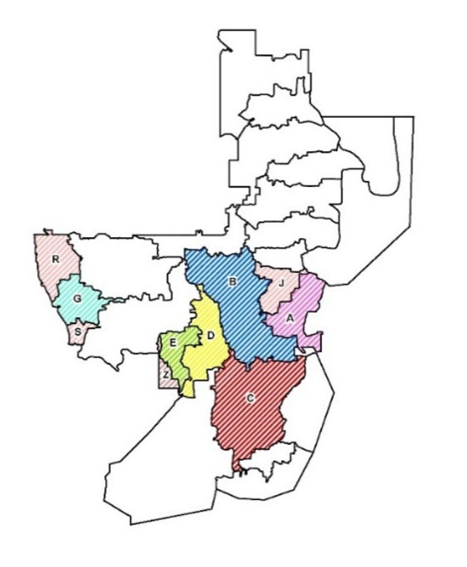 LWES was part of the team that prepared a Stormwater Master Plan for the City of St Petersburg. This project covered an area of 137.6 Sq-miles and had over 240 miles of shoreline containing 26 different regional subwatersheds ranging from 1 square mile to 9 square miles in size. LWES oversaw the development of the Stormwater Master Plan for approximately 37% of the City area (See Map) in accordance with the SWFWMD Guideline & Specifications (G&S).
LWES delineated around 6,000 of the 12,600 basins using Esri ArcHydro Tools. Catchment delineations were created to model all 18-inch and larger pipes. Field reconnaissance and survey data were collected to complete the hydraulic inventory within the watershed using SW Maps and additional topographic data using Trimble Geo 7x.
Model information consisting of 22,500 nodes and 22,900 links was input to the GWIS 2.1 geodatabase for reviewing and analyzing model information. ArcMap with the 3-D Analyst and Spatial Analyst extensions were utilized to develop the geodatabase and associated content.
Land use conditions for the entire City were evaluated for proper presentation of directly connected impervious areas, soils conditions, and infiltration parameters. Florida Land Use Cover/Code Classifications (FLUCCS) were modified for proper hydrologic conditions presentation. The Green-Ampt methodology was used for infiltration parameters.
The created ICPR4 model was calibrated to tropical storm Eta using 2 km hourly Doppler rainfall data. The results from the associated design storm simulations were used to develop floodplains and analyze the existing level of service (LOS) conditions throughout the City.
 Best management practice (BMP) alternatives were developed to address flooding conditions, water quality improvement, and resiliency to sea level rise.
The project required extensive coordination between different internal team members and external partners.
Quality assurance and control measures were established to ensure all staff followed the proper methodologies and common approach in parameterization, inter-boundary flow transfers and calibration. Quality control was implemented at several levels by applying topology rules, and in-house developed tools and measures to ensure consistency and accuracy throughout the City.